
Searching for oil in Israel
How do we decide where to look for oil in Israel?
FIND A FAVORABLE PLACE
First we go to a place that is favorable for finding oil in Israel. In order to do this, geologists have to reconstruct the geologic past and determine where the ancient seas are located beneath the surface of the earth today.
Geologists first examine and study the rocks that are present on the surface. The most favorable areas in which to study the rocks are along river banks and fresh road cuts where the rock formations are laid bare. Of course there are many areas in Israel where rock formations are found naturally exposed at the surface in the many areas that do not have much vegetation.
These various formation are then studied to see in which direction and how steeply they dip or slant beneath the surface. By projecting these formations down to thousands of feet beneath the surface, the boundaries of these ancient seas are found.
This explanation is over-simplified of course; the actual study is much more complex.
We not only have to find the ancient seas, but we also have to find the sand and shale present in the correct ratio to each other. The correct amount of shale has to be present for the oil to have formed and the correct amount of sand has to be present to serve as a reservoir for the oil.
We can determine the presence of the ancient seas and we can determine if the correct ratio of sand and shale is present but more detailed study is necessary in order to pinpoint the potential oil traps.
MANY FIELDS
The ancient sea that we have discovered may cover several hundred miles. Within these limits there are possibly dozens or even hundreds of oil fields in all shapes and sizes. The problem, of course, is finding these fields. The cost of drilling a well varies from millions to tens of millions of dollars depending on several factors, such as depth drilled, hardness of the rock formations and other technical problems.
Drilling in Israel is a lot more expensive than drilling in the United States for many reasons – equipment availability, licensing, environmental laws, archaeological checks, etc.
Because of the high cost of drilling a well, a tremendous amount of planning and testing has to be done in order to cut down the odds of drilling a dry hole as much as possible. Even then, utilizing the most scientific methods available, approximately eight out of every nine wells drilled are dry holes.
Out of hundreds of square miles that can be a potential oil producing area, how do we decide exactly where to drill a well?
There are four basic ways that we decide:
1. SURFACE GEOLOGY
Just as the name implies, this is a method by which the surface of the earth is studied and predictions are made as to what type of structures lie beneath the surface. This is the oldest scientific method and the most frequent method used in the early days of oil exploration.
It must be kept in mind that a geologist can never tell if there is any oil present below. What he looks for is a structural trap that might contain oil. Sometimes the structure that exists thousands of feet beneath the surface is reflected at the surface and can be seen.
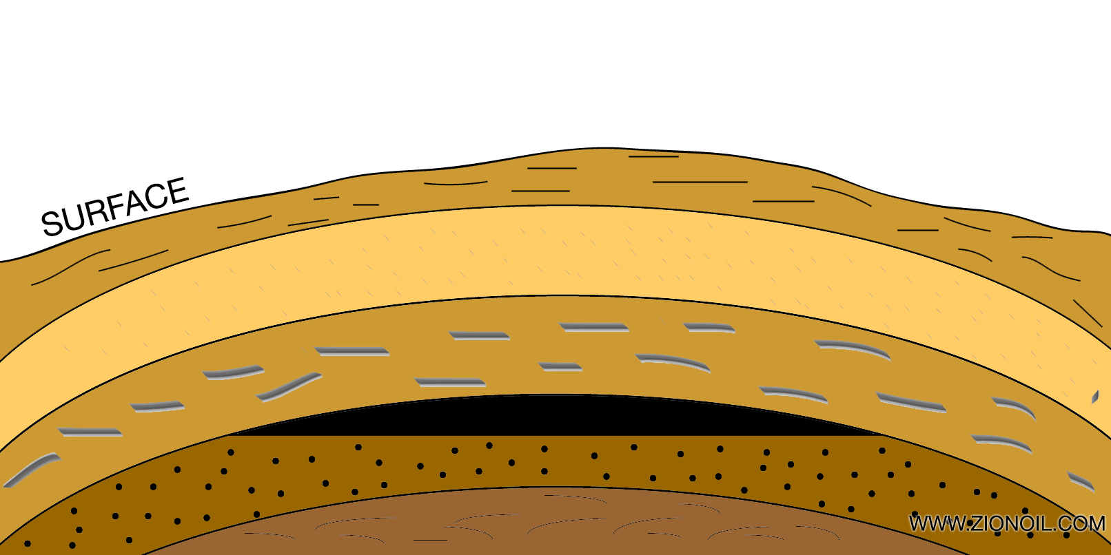
If there has not been much erosion at the surface, the structure of contour of the surface is the same as the formations below the surface. In this case, a geologist would recommend drilling on top of a hill at the surface.
Most of the time however, a hill or mound present at the surface is due to erosion and does not mean there is a similar structure deep below.
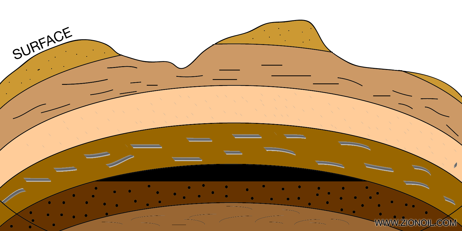
In most cases, the surface has been eroded by wind and water and does not reflect the structure of the formations beneath the surface.
This determination can easily be made by a geologist.
2. GRAVITY METER AND MAGNETOMETER
These two instruments measure the density and magnetic properties of the rock formations beneath the surface of the earth. These instruments are utilized by flying over an area in an airplane.
Only large structures can be found by this method; smaller structures do not usually show up on the records.
3. SEISMOGRAPH
More oil has been found by the seismograph or seismic method than by any other means. This is the method by which small charges of dynamite are exploded in a whole that is drilled abut 75 feet deep. The sound or shock waves go down into the earth and as they hit the different layers of sand and shale, they bounce back up to the surface and are recorded by small timing devices that have been placed on the ground.
By measuring the amount of time that it takes for the sound waves to bounce off a formation and come back to the surface, it can be determined how deep the formation is below the surface of the ground (watch video below).
It is worth correcting another misconception at this point. Some people have thought that when these shallow 75-foot holes were drilled, the oil company was actually drilling for oil. This is a false impression; the only reason for drilling the shallow holes was to explode the charges. It has also been thought that by making these tests the oil company knew there was oil below.
The truth is that many of these shallow holes are drilled systematically over several square miles. It is only after the seismic information has been taken back to the laboratory, compiled, and studied that an oil company knows whether there is a favorable place to drill anywhere in the area just tested. Zion will outsource some of this compiled data to companies like Eskaton to help interpret the data.
Advanced seismography has allowed the use of large trucks that will literally vibrate the earth instead of dynamite charges. This video shows some current methods of gathering 3D seismic exploration:
4. SUBSURFACE GEOLOGY
By this method a geologist studies information gained from wells that have already been drilled in an area. After each well is drilled to total depth, an electrical instrument is lowered down the well.
This instrument is an electric log and the process is known as “logging a well.” The log shows the depth of the formations and, to some degree, if any of the sands are oil bearing. Geologists use this information to draw geologic maps in order to determine where to drill future wells.
Feel free to ask more questions in the comments below or by tweeting @zionoil .


Interesting description. Can you describe any seismic surveys that Zion has performed? Have you any well logging data from the dry wells that you have drilled? I notice that you do not make any mention of any of the methods that your company has used. What reports have you received from Eskaton?
Hello David, while much of what you’d want is proprietary information, we do have a number of our 2D seismic lines published. You might want to set up a call with our Geoscience consultant to get more specific questions answered?